Case Study: Upgrading a Major Freeway
Project Information
Name: State Route 14,
Camas-Washougal, WA
Product: AB Vertical
Size: 70,000 ft² (6,500 m²)
Wall Builder: Tapani Underground Inc.
Battle Ground, WA
Allan Block Manufacturer:
Oregon Block and Paver Manufacturing
Prineville, OR
State Route 14 is a freeway that runs East and West along the north side of the Columbia River in Southern Washington starting in Vancouver. Though SR 14 narrows from four lanes to two at the West Camas Slough Bridge, most of the congestion and collisions on this section of highway were caused by the signals at Union and Second streets. Backups at the signals made the bridge bottleneck worse. Washington State Department of Transportation (WSDOT) called for widening of the freeway in order to improve safety, increase traffic capacity, and reduce travel time along a heavily used stretch of this road near Camas and Washougal.
Plan
The plan for SR 14 was to remove the signals and widen it from two lanes to four from the end of the West Camas Slough Bridge to just east of Union Street. Also, a new bridge on the east end of Lady Island and a new split-diamond interchange at Union Street and 2nd Street was to be built. Since the section of road was highly traveled, careful planning of the sequence and phasing of the construction was required to allow traffic to continue through the construction zone and still allow room for storage of construction equipment and materials.
The Allan Block retaining wall blocks that were approved by Washington State Department of Transportation (WSDOT) were provided by Oregon Block and Paver Manufacturing. The construction bid for this Design/Build project was awarded to Tapani Underground Inc. in part because of their status as a Certified Allan Block Contractor as well as their vast construction experience. With a Design/Build construction format the project moved along at a fast pace and FEI provided design solutions to numerous items along the way.
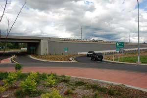
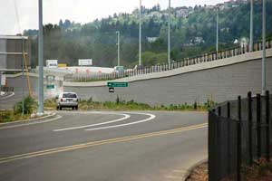
The project improved safety along SR 14 by adding median barriers throughout the project area, increasing capacity and reducing travel times to accommodate residential, commercial and industrial growth. The project required several retaining walls with over 70,000 ft² (6,500 m²) of AB Vertical retaining wall units with the tallest walls just under 30 ft. (9 m) in total height. The 9 walls on the project measured just short of 1 mile (1.6 km) in length.
Design
SR 14 was a WSDOT project so it had to be designed to meet AASHTO LRFD design methodology. There were a number of design challenges that needed to be addressed and local engineer Bill Smith of FEI Testing and Inspection provided the detailed AASHTO LRFD wall design. The project is along a highly traveled section of road and due to the very tight corridor the design required a standard WSDOT high impact crash barrier and moment slab directly above the wall facing in several portions of wall. A detailed analysis of the vehicle impact load and the overturning moment force at the top of the wall was needed to properly design both the wall and the impact barrier.
Since portions of the walls were capped off with the standard WSDOT high impact crash barrier and moment slab then this meant the drop structure locations for storm water runoff would interfere with the continuous slab. The drop structures also were deep enough that there was direct geogrid interference as well. This called for some time to be spent considering how to address the challenge.
Multiple design options were considered and presented to WSDOT for the facing side and the reinforced side of the drop structure. The first was to have the drop structure built as a rigid structure to transfer the facing loads back to the reinforced mass. The proposal was for the Allan Block facing to be physically attached to the side of the drop structure by using concrete anchors and casting the Allan Block cores solid, capturing the anchors. On the grid side, a common wall attachment technique was suggested and that was to attach horizontal spreader bars, using embedded anchors, to the side of the drop structure and have the geogrid layers wrapped around them to form a continuous attachment.
The second proposal considered a variation of the attachment on the mass side. By using a geogrid wrapped wall design up against the side of the drop structure, the spreader bar and anchors could be eliminated. After much review, WSDOT rejected both proposals because in the end, they decided that an option where neither the wall nor the grid was attached to the drop structure would be best for them.
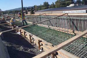
The final solution then was to use the geogrid wrapped wall design with the interrupted grid layers on the mass side of the structure. On the facing side, WSDOT and FEI agreed to utilize the hollow core of the Allan Block units by constructing a fully reinforced wall with both horizontal and vertical reinforcement. The vertical reinforcement would be tied directly into the moment slab structure above forming a continuous structural connection. This application extended a few feet to either side of the drop structure and fully satisfied WSDOT’s requirements.
There were some other design items to consider as well for the walls. There was a set of existing utilities that ran perpendicular to the walls in a few locations. These utilities could not be disturbed and their precise locations were unknown. For the sections of walls where the utilities were generally located, a shallower embedment depth and a structural footing was used to bridge over them. Vertical control joints were located on either end of the structural footing sections to accommodate any potential differential settlement.
The project required a high level of detail and accuracy in both the design as well as in the plans for construction. The wall needed to be carefully designed and laid out so that it lined up properly with the bridge abutments for the project and also fit within the property easements while still allowing room for construction activities. FEI Testing and Inspection used the .dxf output feature from the AB Walls design software to precisely align the wall to the required project stationing and offsets. They also labeled every step up and step down location for the project so that the precise wall positioning could be achieved and the locations could be matched to the bridge abutment positions.
Build
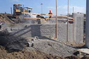
Other items that were closely monitored during the construction phase were the soil compaction, soil testing, and wall alignments. Proper soil compaction is a critical element to a properly constructed wall. WSDOT had a closely supervised compaction testing schedule for all of the walls. This ensured that the structural fill used on the project was properly placed and that it met with the design requirements for a project in a seismically active region. Additionally, site surveyors worked closely with FEI and Tapani Underground to carefully monitor and control the wall alignment during construction. Careful layout and close attention to proper leveling techniques ensured that the walls properly aligned with the bridge abutments when all was said and done.
Effective communication and coordination amongst the manufacturers, designers, contractors, and government officials allowed the SR-14 project to run smoothly from start to finish. The SR-14 expansion project was more than a successful retaining wall project; it was a valuable project for the local community, providing better access, traffic control and above all safety to the highly populated area.
